Earlier this month I spent a week travelling to archaeological sites in Middle Egypt with a group of Egyptology students from the universities of Leiden and Leuven. The trip was a rare chance to visit places that are off-limits to non-Egyptologists in a part of the country not often visited by foreigners; but it was also a great opportunity to produce a georeferenced addendum to the trip report, with a view to giving it some archival value, as well as making these places come alive for others.
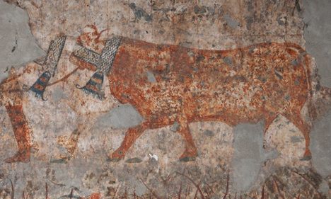
Oxen with scarves, on a wall in the tomb of Djefai-Hapy, Asyut
Here’s the end result that I will write about in the rest of this post — a KMZ network link that is best opened in Google Earth, as it currently has the best satellite imagery of the region.
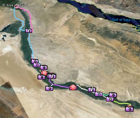
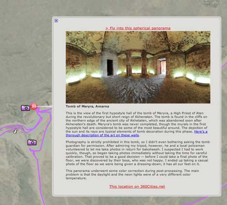
The returned KML contains a folder with georeferenced photos uploaded to Flickr, georeferenced 360-degree panorama photos uploaded to 360Cities, destination placemarks, daily tracks, and — turned off by default — every single track point collected during the trip, with popups detailing our movement. The panoramas and photos have captions, while the destination popups contain links to further information on the web.
The making of the KML:
For the duration of our trip, I had a GPS unit in my rucksack, gathering data. I used a Garmin Oregon 300, which proved to be very robust and doggedly determined to stay locked onto its satellites — often even well into a rock tomb, with just a small opening to the sky. It would eat a pair of AA batteries per day, and every evening I also made sure to save the day’s readings into a track. Because I had a laptop with me, I also backed up the data to my Mac daily using the free LoadMyTracks, saving both GPX and KML versions of the data. The Garmin can keep multiple days of readings in its memory before filling up, but I wanted a redundant set of data.
At the start of the trip I made sure to calibrate the time on my GPS with the time on my camera, and then took pictures and 360-degree panoramas at will. (I’ve already written up how I make my panoramas.)
Once home, I georeferenced my photos using the free GPSPhotoLinker for the Mac. I gave it all the GPX files I had from the trip — GPSPhotoLinker seamlessly collated them, and then batch-processed the photos to a time-weighted average of the closest track points. After editing them in Aperture for Mac, I uploaded a subset to Flickr using the FlickrExport plugin. Flickr can read the EXIF coordinate metadata, so all the photos in the trip’s Flickr set are georeferenced. I also wrote detailed captions for each uploaded photo.
I then used Adam Franco’s still unique (to my knowledge) Flickr Photo Set to KML web app to create a KML file that references the Flickr photos in the set, and also shows their captions. The app works well but hasn’t been updated in a while, so the resulting KML needed some tweaking, for example to make sure it references the newer default Google Earth icons.
Turning to the 360-degree panoramas: Once I was happy with them, I exported a 100% quality full-size JPEG of each panorama — weighing in at 32MB and around 12,000×6,000 pixels per file — and uploaded these to my account at 360Cities. For each photo, 360Cities lets you select its location on a map, either by dropping a pin on a Google Map or by entering the exact coordinate data. As you can zoom in a lot closer on the imagery in Google Earth than on Google Maps, I made accurate new placemarks for them in Google Earth and then copied their coordinates into 360Cities.
360Cities also has a cool tool that lets you align your panorama with the compass. As a result, inside each panorama hosted at 360Cities, there is the option to navigate to nearby panoramas by clicking on hotspots in the appropriate direction. To accurately align my panoramas, I often found myself comparing landmarks in Google Earth to the view in the panorama. With Google Earth aligned to north, it is quite easy to get the orientation right to within a few degrees. And for each panorama in 360Cities, here too I added a detailed caption.
360Cities provides a downloadable KML file for all the photos by a specific photographer, including captions. I used this file as the starting point for my panoramas of Middle Egypt — 360Cities does not yet support sets, so I deleted the panoramas I took of Sweden this past summer from the resulting file.
(And 360Cities is also about to launch an embedding function for panoramas. As soon as it goes live, I will replace this text with an embedded panorama.)
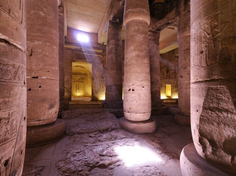
Inner Hypostyle Hall, Temple Of Seti 1, Abydos, Egypt
The tracks were very easy to make: I just used the files produces by the import-as-KML function of LoadMyTracks.
For the individual track points, I needed some heavy artillery, so I turned to Adam Schneider’s excellent GPSVisualizer web app. It can extract track data from GPX files, analyse them and then export them as time-stamped KML placemarks with popups that contain precise speed and direction data. This is not interesting to most people, but it does create an easy way to verify exactly what we were up to when and where, and where we were going and how fast — if only for archival purposes.
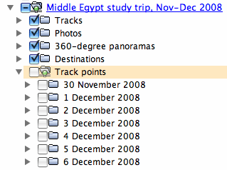
Next: Bringing together these individual KML files into one big file, with simplified, coordinated styles. Here, unfortunately, it was just a matter of having to manually ogle the KML markup in a text editor (I use BBEdit for Mac) and adding/tweaking the required tags. The KML reference is handy for this. The collection of individual trackpoints was simply too huge, so I turned that into an optional download via a network link. I gave each day’s track a separate color (and hence style), and created separate styles for the photo-, panorama- and destination placemarks.
Because in the future I might change the contents of this file, I am distributing a small public network link with a permanent URL that automatically uploads the latest version of my file. Downloading the network link today doesn’t mean an outdated version of the content tomorrow.
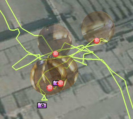
And there you have it. There are many different ways to navigate the data — chronologically, geographically or by content type. One interesting use of the trackpoints is to turn them all on and then set up Google Earth’s timeline navigation tool so that it shows only about an hour’s worth of trackpoints at a time. Then press play and watch the trip unfold in a kind of balletic frenzy.
I learned some GPS-related things on my trip:
- GPS-enabled mobile phones are no substitute for a good, dedicated GPS device. If I have my iPhone running a GPS tracking program, it drains its batteries in a few hours — and meanwhile, I can’t use my phone for anything else. That’s very suboptimal. After trying for almost two years with my Nokia N95 and now with my iPhone, the verdict is in: It’s can’t replace a serious GPS device. Sure, it’s good for saving you the trouble of telling it where you are right now when you want to know something about your environs, but anything more ambitious is not ideal on a mobile phone.
- On-camera GPS units face a slightly different problem. Sure, it’s great to be able to have your photos georeferenced as soon as you take them, but since you are unlikely to do anything with them until you get home and edit them, adding coordinate metadata via an application like GPSPhotoLinker is a minute extra step, and it means you can buy a more versatile GPS device than a camera-specific unit. Furthermore, why make your camera any more bulky than it needs to be? A GPS unit need not be affixed to the camera, and can be tucked away safely in a nearby bag.
Awesome KML file… very educational. I agree with your two conclusions, but hope that some form of location information can more easily be stored with photos w/o the need for GPSPhotoLinker or its equivalent.
I’m a big fan of HoudahGeo for geoencoding of photos. I can plug the GPS in and it’ll automagically sync with the jpg/raw files. But it’s ~$30 or so, but I find it very useful.
I read somewhere recently that GPS use is illegal in Egypt. Was there an exception granted for the clearly educational use?
Like Mike, I too am curious about the use of GPS which is generally not allowed for use by civilians in Egypt. Was there an exception made or was your use just “on the sly”?
Yes, there is a law against GPS in Egypt, but just like traffic laws, it isn’t enforced. I just had my unit dangling from my bag and on the dashboard for the entire time, and in front of countless police officers at checkpoints, but they either didn’t care or didn’t know what it is. (Remember, 99% of Egyptians can’t afford one.) Probably both. And maybe some of them just assumed I had permission:-) as we had permission to do other stuff like visit obscure sites.
Stephan, what immersive KML! I love it. The 360 panoramas are amazing. I’ve spent a good hour panning zooming through just a few of them. They’re so detailed when zoomed in.
So the KML used to create the 360 panoramas and the flash player that’s opened in Google Earth, this is straight out of 360Cities? I know you mentioned you tweaked some of it….but how much? I would love to do something like this.
“GPS-enabled mobile phones are no substitute for a good, dedicated GPS device. If I have my iPhone running a GPS tracking program, it drains its batteries in a few hours — and meanwhile”
get a real smartphone and cut down this process by 50% at least. x1 comes to mind… but you right, toys are not meant to be substituted real equipment. my dongle and camera are collecting dust now.
cool post tho, i love geotagging
Wonderful post, Stefan – one of the most interesting and useful blog posts I’ve read all year, anywhere.
Now all we have to do is get you a GigaPan robot…
Thanks, Ron, even though you wrote that on Jan 1:-)
Steve, in the 360Cities KML, I removed all the tags containing panos from before the trip, and then also removed some of the contents inside the tag.
For the record, I was in Las Cruces, New Mexico when I wrote the comment, thus still in 2008.
I have the N95 8GB and although the batteries do drain more quickly when using GPS (5-6hrs) it is the camera or the use of the screen that really cuts this time down coupled with the phone searching for distant cell sites if you’re out of town. I def. don’t think it’s all the fault of the GPS. I’m surprised to hear that the iPhone can’t be used as a phone while running a GPS tracking program.
John: the iphone can be used as a phone while using the GPS, but not a different application…
iphone osX only allows the use of one application in order to keep the OS sanppy and the battery drain by apps running in the background low!
as to egypt and GPS, i highly doubt that egypt is able to enforce it, but iphones for example disable the GPS, as do nokia and any other smartphone with GPS, when using an egyptian cell provider. the iphone is hackable to circumvent this…
and since many people are poor and can’t read or write, incl. police, it’s nearly impossible for them to spot a GPS, they simply have no clue what’s going on… the law is archaic and shows how backwards the country is in some regards;-(
Bonjour
Je suis surpris de lire qu’il y a une chapelle de Min en Abydos dans le temple de Sethy 1er?
En fait il s’agit de la chapelle d’Amon
Amun = Min in some contexts, especially when the fertility aspect is brought up (so to speak).
Egypt highlights– hope that some form of location information can more easily be stored