Way too much cool stuff, way too little time, so forgive the rapid-fire delivery. Much of the below could do with an own post…
- The Earth is Square‘s Chad Zimmerman does some excellent work creating a geospatial visualization of refugees and internally displaced people in Somalia. He first created a plugin for NASA World Wind, and has now released a version in KML, usable in Google Earth (direct download, or in data in Google Maps). The only real difference between the two versions is the resolution of the underlying imagery, which depends on the client you’re using, as well as any image overlays you may have.
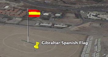
- Neal Sweeney wrote in to point out that “someone has created a model of a spanish flag and placed it in the middle of Gibraltar which is a British colony. […] I wonder if this will start a trend of people ‘capturing’ other contentious places?” Indeed, if you have 3D buildings checked, there is huge spanish flag right here. I wonder how it climbed the popularity rankings in 3D Warehouse sufficiently for it to be included in the “best-of” layer… Could this be the first case of Google geobombing?
- GeoServer 1.5.0 is out. Improvements include “easier adding of data through the web admin tools, better support for Google Earth KML, performance and scalability improvements, and as always a heap of bug fixes.”
- A New Google Earth-based game, by MIT’s Ravi Purushotma: Google Earth Tag. I have not, unfortunately, had the time to try this, but don’t let that stop you — it looks very intricate.
- The Map Room links to an opinion piece in the Laser Altimetry of the San Andreas Fault Zone in KML.
- Dutch gaming TV program Gamekings tackles GPS for sports and geocaching. Google Earth features prominently in these two YouTube segments.
- tobedetermined!, just for the hell of it, has made it it possible to record a position history trail for his sessions Google Earth. It’s a proof-of-concept Python script that uses the Windows version’s API, but this is definitely a good idea in search of a practical application. Perhaps for games?
- From the people that brought you HeyWhatsThat: Elevation Mapper. draw a polyline on the map, get the elevation for the route as a chart. (Beta)
- Randall Newton over on AECNews has an interesting datapoint regarding the relative popularity of SketchUp: “Jesse Devitte, which was an investor in SketchUp, said that SketchUp daily downloads now exceed monthly downloads before the acquisition.”
thanx
style