Two GPS community sites were brought to my attention almost simultaneously today. Both allow you to upload, edit and share GPS data, and both offer exporting to KML.
First up: Wikiloc, by Jordi L. Ramot. Jordi writes up his site far better than I can:
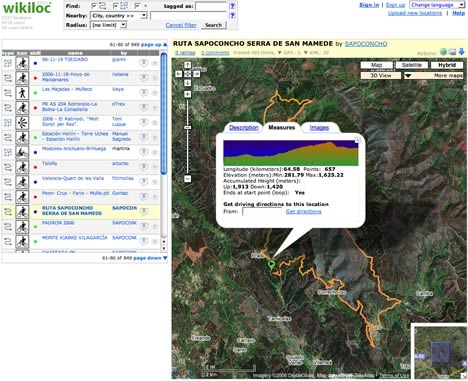
I’ve recently developed a completely free web app to discover, post and share GPS information on the web. Posting a GPS tracklog/waypoint (in gpx format) takes less than a minute and immediately you can visualize it on Google Maps, in 3D in Google Earth, you get the elevation profile, distance, accumulated heights, driving directions to the trail head, attach pictures too. For GPS trails in zones with Web Map Services registered in Wikiloc, you can even visualize them overlaid on USGS (or Spain’s ICCs, etc…) maps both in 2D (Google Maps) and since yesterday in 3D (Google Earth) too (I’m pretty excited about the latter and I’ve written about it in my latest weblog post).
Wikiloc won the Google Maps Mashups contest prize some weeks ago and since then it has had good acceptance from users, at the moment mainly in southern Europe although there are already some authors from the US like hikerdave. I’m surprised and glad that my little web app is being known in other countries too. So far all user feedback has been great and I’d love to let the app be known in other countries.
Glad to help:-)
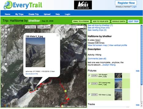
The other GPS sharing site is Everytrail: Here too you can upload GPS files, add waypoints, photos, notes… and then share them. In addition to exporting the edited track to Google Earth, you can also add it to your website via an embedded iframe. Another nice touch: If you have a PC, you can download a client that will automatically transfer tracks from your GPS device to EveryTrail online. And, of course, it’s also free.
The person behind EveryTrail is Joost Schreve, who explains the motivation behind it in an interview with Tech Digest:
Everytrail has its roots in founder and CEO Joost Schreve’s own travels around the world, and frustration at the fact that it wasn’t easy to share his photos and experiences online. Having created various websites and blogs, he and his friends decided there must be a better way. Hence Everytrail.
The whole thing is an interesting read. (I found EveryTrail via Jeepx.)
And a few weeks ago, Ogle Earth wrote up Crankfire, a GPS community site for bike trails. So now there is Wikiloc, EveryTrail and Crankfire. I think we have ourselves a promising new genre of community site here. Check them all out.
(PS, don’t forget the GPS community sites for pilots: flightlog.org, goflying.org and Paraglidingforum.com.)
[Update 08:29: Wikiloc also lets you embed maps in your website, I’ve found out.]
You may want to add Mtbguru.com to this list as well ;).
We went live about two weeks ago and we’re doing similar things to the sites you’re describing (with a slight emphasis on mountain biking), but in addition we automatically geotag pictures taken during the trip (i.e. with no need for user intervention) and display them on the map and link to them in a kml file.
Google’s ‘Using Google Earth’ blog writes about us here.
See a related story on the Google Earth User Blog:
http://googleearthuser.blogspot.com/2006/11/yesterday-i-wrote-entry-that-mentioned.html
When will we get support for Flickr integration from either of these? Triptracker has something similar to these. They have Flickr integration, but I wasn’t impressed with the website delivery.
Check out Sunday Morning Rides (http://sundaymorningrides.com)…a worldwide GPS community site for motorcycle touring. Sunday Morning Rides is an interactive community portal for motorcycle riders to access, explore, plan, and share motorcycle tracks via a sophisticated ride mapping system that combines GPS, geographic information systems, database, and Google mapping technologies.
Hear what others are saying:
http://news.motorbiker.org/blogs.nsf/dx/03272007092434MWEAPX.htm
http://govm.geospatial-online.com/gssgovm/article/articleDetail.jsp?id=406694
I’ve also recently launched a community driven website that was featured on googlemapsmania.com in January.
http://www.navitraveler.com is a site where you can use a google maps interface to search the world and discover thousands of user entered waypoints. For each point you can add tags, descriptions photos, do wiki-style editing, categorization, filtering, keyword searching, and ultimately you can take a customized data set and export it to POI, GPX, XML/KML, HTML…just about anything you want.
It’s really a lot of fun, and we’re always ready to work with the community to make it better.
Hope you enjoy it.
Thanks,
Ryan
You can also have a look at http://www.livecontacts.com , a GPS community that will also enable buddies to share their location using regular phones (by pinpointing the GSM Cellid)
GPS Touren- Community: http://www.crossingways.com