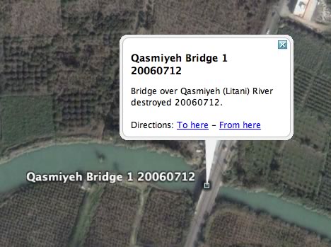
Following up from last night’s post, where I lamented the lack of geospatial documentation of the Israel-Lebanon conflict — I’m glad I didn’t start on a KML file because this morning’s trawl through the newsfeeds brought up an exhaustive and wholly impressive KMZ file documenting with pinpoint accuracy (where possible) the events of the past week on both sides of the border. For example:
Here is the file’s launch page. Leave it to the locals to come up with the most immersive way into this war.
How would I improve it? I’d turn it into a network link, so that it gets updated automatically as content is added; I’d put individual day’s events in folders, so that a timeline can be simulated; and I’d use different icons for different kinds of events — different colors for different actors, and different symbols for rocket attacks, plane attacks, incursions, abductions, etc… But all that takes time, of course, and preferably a spot outside of a warzone.
(Finally, a KML feature request: It would be nice to be able to categorize KML objects, so that you could filter for, say, just Hezbollah rocket attacks, or just Israeli bombardments on July 18.)
(Via NL-Outsidethebox)
You can also see this KML file in google maps by pasting the KML URL into the search box, or just follow:
http://maps.google.com/maps?f=q&hl=en&q=http://almashriq.hiof.no/lebanon/900/910/912/maps/Lebanon_July_2006.kmz&safe=active&ie=UTF8&om=1
True, but the file is too big, so it ends up showing just a portion, which happens to be mainly events in Lebanon, and then you’re in danger of being called out on bias, etc… Best not to go there:-)
Hey Stef – Good find. I realized that you can view this KML file in Google Maps so I made a mention of it over on GMapsMania!
Israel should be condemned.
Please refrain from making overtly political statements on Ogle Earth, as they really don’t add much value, considering this blog’s brief.
There are plenty of places on the web where criticism of Israel (and/or Hezbollah) is topical and useful. Please use those.
Lebanon and Israel: both sides suffering
http://www.geocities.com/war_in_haifa
I really do wish you’d explain to me how your comment and link is at all related to GIS or Google Earth.