How would New York’s skyline look if it once again held the world’s tallest building? It’s a question I’m sure many New Yorkers have asked themselves. I know I have.
New York hasn’t been home to the world’s tallest building since 1974, when the title went from One World Trade Center to Chicago’s Sears Tower. Since then, it’s shifted to the Petronas Towers in Kuala Lumpur (undeserved, in my view — anyone can add a spire) and subsequently to Taipei 101. Currently under construction is the Burj Dubai, which will be at least 700 meters tall when completed in 2008, easily making it the tallest structure anywhere.
Freedom Tower is set to replace the World Trade Center, but it has received plenty of negative criticism for its uninspired design. What if…
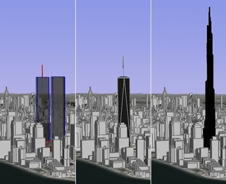
With Google Earth, what-if scenarios are easy. The application already supplies a layer of existing buildings for New York City. Just add your own. Here’s some comparison views of the WTC, Freedom Tower, and Burj Dubai:
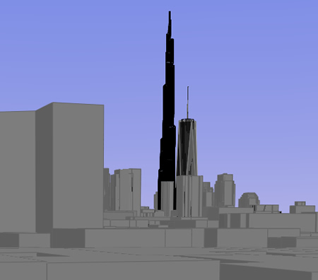
Here’s what Freedom Tower and Burj Dubai would look like from the roof of my ex-apartment in the East Village:
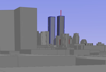
It’s remarkable how accurate Google Earth’s base layer is. Here is the view from the same roof up until September 11, 2001:
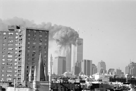
Compare it with the photo I took that morning as the towers burned (complete series here):
Here is the KMZ file (580k) containing all the content for this post, so you can try out the view from your own vantage point. Credit for the Burj Dubai goes to ZNO blog. Credit for Freedom Tower and WTC models: Equitus.
(Technical details: I had hoped to import Burj Dubai into SketchUp and then export it to elsewhere on Earth, but the Mac beta of the Google Earth plugin for Sketchup proved a bit too buggy. Instead, I opened the KML file in a text editor, and then did a search and replace on the most significant digits of all the coordinate pairs. It worked beautifully, though there is one caveat: The physical distance separating units of longitude depends on the latitude. Dubai is at 25 degrees north, where 0.1 degree of longitude spans 10km, whereas Manhattan is at 41 degrees north, where 0.1 degree of longitude spans 8.45km. So the model of the Burj Dubai used for this post is actually 15.5% too narrow, east-to-west.)
Nice work Stefan! I’ll write you up in my blog tomorrow! :-) Didn’t know you had seen 9/11 in person.
No CN Tower? Tragic.
A
I’m not convinced by these renderings. WTC was 1368 ft, while the top floor of FT is about 1350 ft and the spire goes up to 1776 ft. Burj is 2300 ft. But the difference between Burj and FT seems much larger, to my eye, in these renderings. Still, this is crazy: everyone remembers how out-of-proportion the WTC was. Burj is crazy tall.
Impressive piece of journalism 2.0: personal and touching, tech savvy yet easy to be understood, mixing media (text, images, the kmz piece of software), a truly interesting topic. Congrats.
Felix, from the Wikipedia article:
“Its exact final height remains a closely-guarded secret, but is believed to be at least 705 metres (2,313 ft).”
I just looked at the KML and the building you see in these pictures goes to 743m. Perhaps ZNO knows something we don’t, perhaps its an inspired guess, but if not, lob 5% off the height — which is not that big a difference.
Mooi stuk joernalisme en technisch vernuftig. De NYT zou dit moeten overnemen…!
I really like the topic and the pictures helped a lot in comparing the height of the Burj Dubai with the Freedom Tower.
Look at the X-Seed 4000. Its 13,000 ft
Thay should have rebuilded the twin towers back the way thay were its not New York those building were remarkable in there design the way thay look tall with there narrow windows