There are border disputes aplenty, but when Reuters reported on Feb 5 that the government of Cambodia had sent a letter of complaint to Google about how the Thai-Cambodian border is displayed in Google Earth and Maps in the vicinity of Preah Vihear Temple, I was intrigued.
The complaint? The displayed border is “radically misleading”, “devoid of truth and reality, and professionally irresponsible, if not pretentious,” and, in case that wasn’t clear, “very wrong and not internationally recognised”.
A rainy Shanghai Sunday afternoon spent googling for context led me to a fascinating story, and also some thoughts about the legitimacy of Cambodia’s claim.
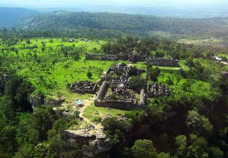
Although I had never heard of it previously, the Preah Vihear Temple is an 11th-century Khmer architectural gem situated atop a cliff straddling the Thai-Cambodian border. To the South is a steep drop affording panoramic views of the Cambodian plains; to the North, the Thai landscape rolls gently downhill. The border between Thailand and Cambodia in this region mostly follows the watershed demarcated by a line of bluffs extending East to West, with the Preah Vihear Temple on the edge of one of these.
I wrote “mostly follows” in the paragaph above because there was a significant deviation from the watershed when the map was drawn. Wikipedia distills the story:
In 1904, Siam [modern-day Thailand] and the French colonial authorities ruling Cambodia formed a joint commission to demarcate their mutual border. In the vicinity of the temple, the group was tasked by the two governments to work under the principle that the border would follow the watershed line of the Dângrêk mountain range, which places nearly all of Preah Vihear temple itself on Thailand’s side. In 1907, after survey work, French officers drew up a map to show the border’s location. However, the resulting topographic map, which was sent to Siamese authorities […] showed the line deviating from the watershed in the Preah Vihear area, placing all of the temple on the Cambodian side. In fact, on that map, the temple is shown, and the border is drawn clearly north of the temple.
At first, this border appears to have been accepted by both sides: Thailand made no objections to the use of the French-drawn map in international forums, and when a Thai prince paid a visit to the Temple in 1930, he was received by a French colonial official on behalf of Cambodia.
Then things went awry. In 1954, after the French had withdrawn from Cambodia, Thai troops occupied the temple. Tensions rose, and the case went before the International Court of Justice in 1959, which in 1962 sided 9-3 with Cambodia — not on the grounds that the map was fair, but rather that Thailand had not disputed the map over a period of many decades. (Here is the ICJ judgment.) Thailand returned the temple proper to Cambodia, though it did not cede all the territory it had occupied in 1954. Wikipedia again, adding some rather excellent color:
Rather than lower the Thai national flag that had been flying at the temple, Thai soldiers dug up and removed the pole with it still flying. The pole was erected at Mor I Daeng cliff [1km NNW of the temple], where it is still in use.
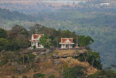
Mor I Daeng seen from the temple. Credit: Wera M @Panoramio
From 1970 on, Cambodia was wracked by civil war. Because the temple is so easily defended, it was the final refuge of the Cambodian Khmer Rouge, whose last remaining forces sued for peace on the temple grounds as recently as 1998.
In 2003 Cambodia built an access road from the Cambodian plain to the temple; previously, road access had only been via Thailand.
Then comes a series of deadly stand-offs, beginning in 2008, precipitated by Cambodia’s decision to submit the area around Preah Vihear Temple for inclusion in the list of World Heritage Sites. Thailand’s government complains that some of the proposed land is under Thai control, so Cambodia reformulates its application to cover just the temple, and resubmits it, this time with the approval of the Thai foreign minister.
That proves too much for Thailand’s nationalist-patriotic opposition, which has never accepted the ICJ’s judgment and feels it is a tacit admission of Cambodia’s sovereignty over the temple. They file suit arguing that Thailand’s foreign minister acted unconstitutionally. The suit is upheld by Thailand’s Constitutional Court, and the foreign minister subsequently resigns, but meanwhile the temple becomes a World Heritage Site, on July 8, 2008.
Soon after, some enterprising patriotic Thai civilians try to plant a Thai flag on the temple grounds, and are arrested by Cambodian troops. This prompts 40-odd Thai troops to take up position in a small Buddhist pagoda that Cambodia claims is in its territory. Thailand rebuts that they are on Thai soil. A troop buildup ensues on both sides. By October, the inevitable occurs and several isolated shootings between troops kill or wound several soldiers on each side. Fortunately, there is no escalation.
In April 2009, the inevitable occurs again and several more soldiers on both sides are killed in shoot-outs amid perceived trespassings across contested borders. Fortunately, there again is no escalation.
And finally, this year, on separate incidents on January 24, 25, 30 and 31, 2010, more gunfire exchanges.
It’s into this volatile environment that Cambodia’s prime minister Hun Sen decides to pay the temple a visit. It has just taken place without incident this past Saturday, Feb 6.
And there you have the context for the complaint made by the Cambodians against Google a few days ago. Now lets go to the maps. Here’s Google’s version of the border, as of February 7, 2010 — in Google Maps:
(Click for the “live” Google Maps)
A closeup:
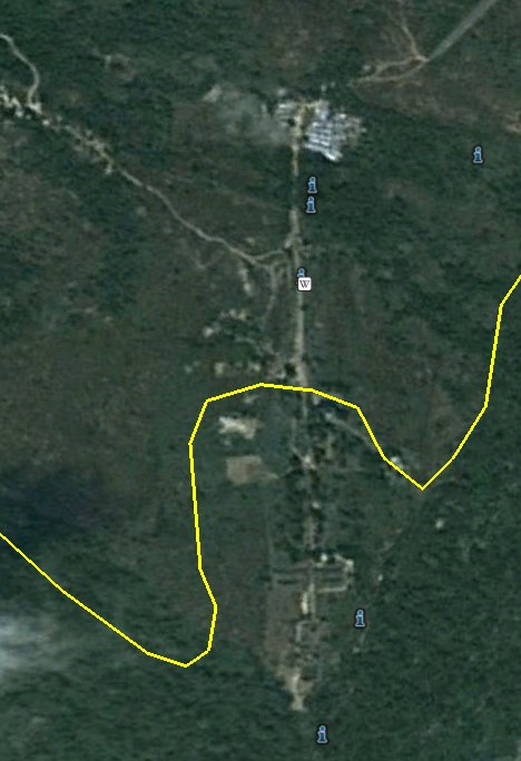
In Google Earth, there is far more contextual data to play with — from Panoramio photos (not all of which are correct or neutral in their positioning and labeling, though many are), Google Earth Community placemarks, Wikipedia and the height data, which clearly shows off the promontory if you fly around it.
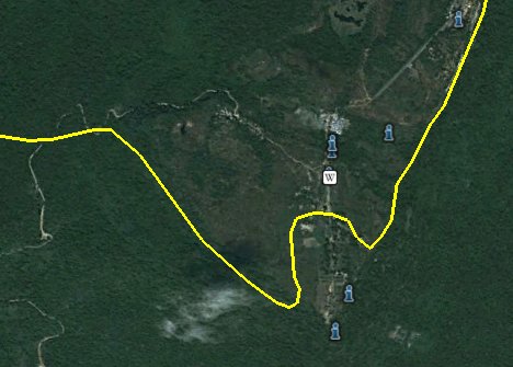
How do these borders compare to the judgment of the ICJ, to the French Map of 1907, and to the “facts on the ground” — the line of control, the roads and the border posts?
Cambodian nationalist-patriotic bloggers had in fact already blogged in ire about Google’s border back in April 2008, as the World Heritage Site bid got underway. The Cambodian case is straightforward: The ICJ ruled that the French map must be respected, so it is just a matter of drawing the border along that line. One blogger even has that French map to show us:
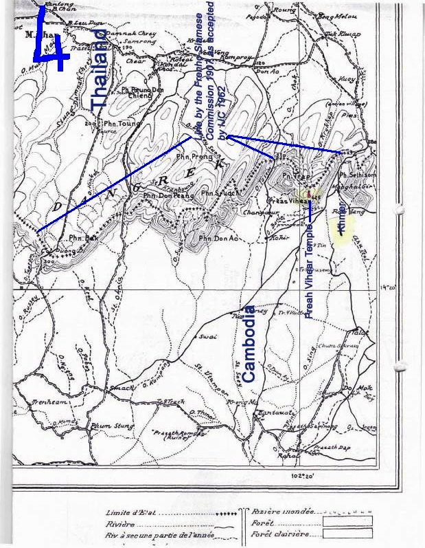
(Click image to enlarge)
Beside it we get another (again, Cambodia-sourced) map that shows the French map’s border versus the border that Thailand recognized in the aftermath of the ICJ’s judgment in 1962:
Thailand’s version of the border is almost identical to the border visible on Google Earth today, and amounts to the maximalist version of how Thailand interprets the ICJ decision — that the temple itself had to be returned, but that the ICJ did not pronounce on the rest of the territory, so that any further transfers of land would need to be agreed on separately.
But what about the facts on the ground? Not having been there, it is difficult to tell with certainty, but there are many clues available. Here’s a quick mark-up KML file with the relevant placemarks:
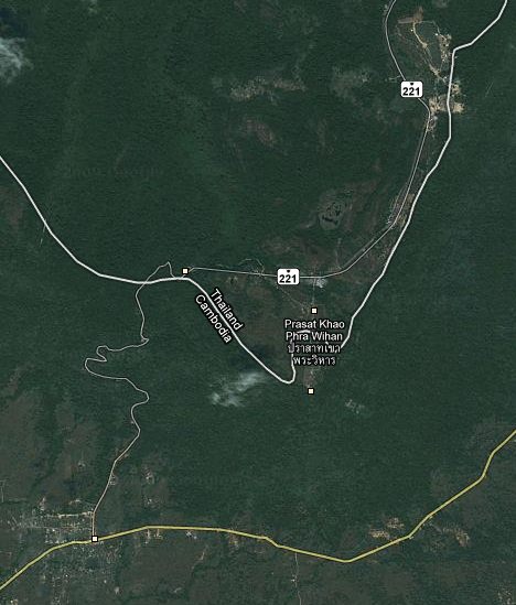
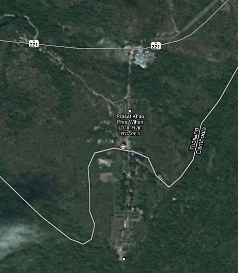
First, there is the road Cambodia built in 2003, which veers through what is disputed territory and ends up at the temple proper, arriving from the West. Presumably, Cambodia has control over this road, or else we’d have heard about it.
Then there is Thailand’s asphalted Route 221, which is clearly seen to end on Google Earth at a point distinctly removed from the temple. Just beyond its end, according to what appear to be reliably placed Panoramio photos, lies the Cambodian border checkpoint.
(Interestingly, in Google Maps, Route 221 is seen to continue past its actual end, and an imaginary stretch sees it meeting up with the road from Cambodia. Wishful thinking, but perhaps a hope for the future.)
Finally, there is the fact that the Thai flagpole, whose flag famously was not lowered, has been repositioned along the cliff edge about 1km further NNW, near to where the present-day Thai border control post is. (See this photo and this photo for the right positioning context.)
All these signs point to what appears to be an actual line of control that lies well inside the border as drawn by Google. Strictly speaking, Cambodia’s complaint has some merit.
But is Google to blame for all this? Is there a nefarious plot afoot to deny Cambodia its rightful greatness under the Sun, etc, and is Google being “pretentious”?
No, of course not. As can easily be verified by turning off border data in Google Earth’s Layers sidebar, credit for the yellow line goes to Tele Atlas, which provides much of this kind of information to Google Earth. Where Tele Atlas gets its data from is another story — most likely, it acquired Thailand’s official border dataset, and used it unmodified and uncritically.
So what would the optimal map of this place look like? In my opinion, it should show both Thailand’s maximal version (which we have today in yellow) and Cambodia’s claimed 1907 map line, though both lines should appear in red (as these borders are disputed). Then, in orange, I’d add a line of control that accurately reflects the reach of both countries inside this disputed area.
Of course, in a perfect world, the ICJ would reconvene and issue a clarification, once and for all letting us know where that border should go, so that there is no more opportunity for wildly diverging interpretations of international law that get people killed.
Postscript: In case you’re wondering what Bing Maps has to say about all this: Nothing at all. The satellite view doesn’t even show the border. That’s certainly one way to stay uncontroversial, but also irrelevant.
Thank you very much for doing this google earth. Now Thai and Cambodian should have the real international border that did not drawn by the French only that make all of us in such problems for years. Now the Freach reapear to wants to have interest in this area again. Watch them people they are comming!
interesting article
good research
thanks
Thanks for the interesting intensive data research. Have a look here (in the lower section): some more maps and observations on the maps and the controversies:
http://tinyurl.com/yd548oz
Norbert Klein
Note the longitudes in the French map above (pvt7-large.jpg) are relative to Paris, not Greenwich!
Their was no problem between the two countrys and worked in harmony untill the un changed the rules, guess everyone has forgotten that???
The UN has a lot less influence over border disputes than a lot of people think.
Many countries have interest in this area for many reasons for their own good therefor Cambodian and Thai must watch them carefully.