(Read an update to this post, featuring imagery from 2009)
Iran’s nuclear program is again making the news cycles after the country admitted this week that it has built a second nuclear fuel processing plant, to complement the one at Natanz.
According to the New York Times, the admission by Iran came after it learned that western intelligence agencies knew of its existence, and indeed the US, UK and French leaders were just now on TV to accuse Iran of having concealed the plant from the International Atomic Energy Agency (IAEA) for all the years it was under construction.
The New York Times has US government sources situating the new plant “inside a mountain near the ancient city of Qum,” and that alas is the most detail we can glean right now from public news sources.
Might it be enough to find this new plant in Google Earth, however? Not with certainty, but one place in particular looks like a very strong candidate. I’ll explain how I found it, you decide how likely it is to be the right place.
First, I turned on successive years of the “Digital Globe Coverage” layer in the “More” directory in the “Layers” sidebar of Google Earth, and went exploring around Qum (aka Qom).
The working assumption is that any satellite image tile taken all by itself as a “special request”, instead of as part of a long strip, tends to be taken at the behest of an organization that has good cause to investigate that region for something it might not have direct access to. This need not be an intelligence agency, it could also be an NGO, for example one that is interested in proliferation issues like ISIS:
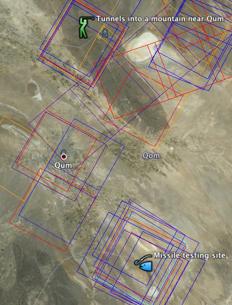
With this search criteria in mind, two areas around Qum are found to be consistently the beneficiaries of such special requests. One of them is an Iranian missile test site some 40km ESE of Qum, and it is not near a mountain. The other one?
Well, it’s a mountain 35km NNW of Qum. And it has two big parallel roads driving straight into it:
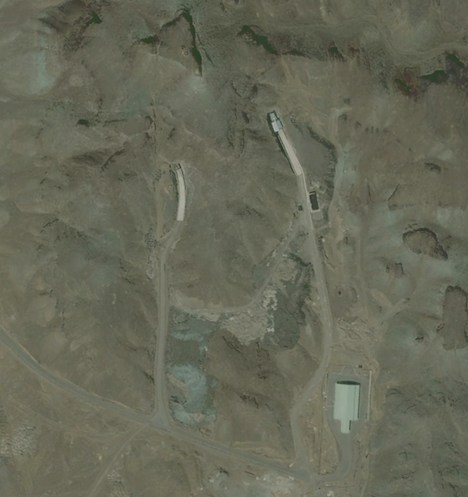
Considering that one-ended tunnels are rare finds, and after a look around Qum to see if there might be other overlooked sites, this candidate site sure looks promising.
Here is the placemark for the location, with a bonus pointer to the missile testing site. Enjoy.
(One weird additional piece of information: The imagery all the way around the mountain is dated August 21, 2005, but the area immediately around the entrance of the tunnel comes with no date attached in Google Earth. Imagery metadata in Google Earth is almost never that granular. The imagery of the tunnels could be newer, as 2005 would be a long way back to be building this plant (though not the tunnel for the plant), but there is no clear seam of a more recent image being overlaid on a base image. So my guess is that the imagery of the tunnel is from 2005 or later.)
Interesting detective work, with a weird implication. Could the Iranians have noticed the high res images in Google Earth and figured out that the world was on to them?
One of the things that makes it a likely site is its close proximity – 10 km by road – to the military airfield at Manzariyeh Airport.
Another nearby possibility is what appear to be hillside bunkers or mines and hangars located slightly to the south, though there are many of these structures scattered over a wide area.
google map: Mordad
There are two security perimeters visible in the image, with a total fence length of around 50 kilometers. One of them parallels a major road linking Qom with Tehran for several kilometers, starting about 4 km north of the irrigation north of the city, and there doesn’t seem to be any attempt to conceal it from the road. So, the locals (and others driving north out of Qom) knew there was some kind of closed facility there. Whether this security perimeter was new is an open question.
More berms, which are visible on a 2003 historical image, are located north of the airfield to the north and west of the white salt flat. These don’t seem to be fenced.
yes, I noticed those bunkers too. Somewhere there have to be ventilation shafts, and a big power substation to power the facility. Good catch on this one.
More tunnels in a hill just east of the original placemark:
http://maps.google.com/maps?ll=34.938243,50.732088&z=16&t=h&hl=en
Associated Iranian Islamic Revolutionary Guards Base
http://bbs.keyhole.com/ubb/ubbthreads.php?ubb=download&Number=828488&filename=20090925225422-4abdac8e733070.72193590.kmz
Turn on the DigitalGlobe image ID overlays. There has been significant and repeated DG coverage of this site over the years. Most recent ID is date May 2009.
Nice finds guys. I noticed also that the bunnkers mentioned while not built in the imagery I am seeing appear to be about 30m across, This seems rather large for ammunition they seem to typically vary from about 15-25 meters in teh examples I ahve seen. also if you look just a bit further south there are a number of pads, they lok like cement pads to me, ringing the mountain. Some (to the NW of that area seem to have shadows making them look, to me, like they are a 90 degree structure like a cement pad and one wall??
Also see http://www.watoday.com.au/national/rudd-iran-nuclear-revelation-profoundly-disturbing-20090926-g6qf.html to straighten out some points. This facility is not complete and has been under construction for years. The controversy specifically regarding the informing IAEA is that it IS under construction but Amedjinehad claims they told the IAEA about this facility already. However, while he is telling the truth.. the fact is, he only informed them at the beginning of this week, not when it was in the planning stages or when it started construction, or….
Interesting stuff. I found a small image on http://www.corriere.it (an italian newspaper) in the article related to the “new” Qom site. With yours, and other info, I managed to place it in Google Earth. Centre coordinate of the image is 34.885264 N, 50.991159 E, which is to the East of the location mentioned in your blog. With a little manipulation, you get the image fitted very nicely. The difference with the 2005 background is remarkable. There seem to be covered tunnel entrances in that one.
The quality of the image suggests GeoEye, but it could be a QuickBird as well. I don’t know how the Corriere got this, but they did a nice job.
To the north of the image, there are obvious signs of a missile site (circular blast walls).
Hope this helps.
Can you post a complete link to the article on http://www.corriere.it – I couldn’t find that image.
The Il Corriere image turned out to be a low-res version of the image commissioned by ISIS. See my latest post on Ogle Earth about that.
Based on examining a satellite photo of the facility, I have determined its exact location:
“Locating Iran’s secret nuclear facility”
hi found it it is here
lat 34º53’5.41″N
long 50º59’38.88″E
It appears to be a massive arms depot from the prolific bunkers surrounding the mountain. It might accidently blow itself up one day soon. Interesting “Star of David” SAM site just west of Qom 34º34’14″N„ɺ50º44’10″E. The bunkers are around the missle site also. That “Star of David” SAM design shows up just west of Tehran in a residential neighborhood also. Not a good real estate investment I would say.
It appears to be a massive arms depot from the prolific bunkers surrounding the mountain. It might accidently blow itself up one day soon. Interesting “Star of David” SAM site just west of Qom 34º34’14″N„ɺ50º44’10″E. The bunkers are around the missle site also. That “Star of David” SAM design shows up just west of Tehran in a residential neighborhood also. Not a good real estate investment I would say.
What are the rectagular earthworks to the SW of your original tunnel entrances?
Nobody seems to be mentioning those tunnel sites that are right ON the IRGC base itself. Are there topographic or map dating considerations that would rule these out?
What are the rectagular earthworks to the WSW of your original tunnel entrances?
i found some writing in the sand at
34º53’7.76″N 50º57’35.22″E
Facility building in process, looks massive…
http://www.terraserver.com/view.asp?cx=499770&cy=3860357&proj=32639&mpp=1.5&pic=img&prov=gx49&stac=7015&ovrl=-1&drwl=-1
Why don`t they let the Iranians know “We know where it is, and so do our predator drones??”