- G. William Skinner: This obituary of G. William Skinner (1923-2008) is a must-read for all aspiring neogeographers: A quick excerpt to whet your appetite:
A central and crucial aspect of Skinner’s thinking is spatial; he was vastly ahead of the GIS revolution in the social sciences, in that he consistently tried to analyze China’s social, economic, and cultural data in terms of the spatial patterns that it displayed decades before the corresponding desktop computation capability was available. I visited his research laboratory at UC-Davis sometime early in the 1990s, and was struck by a couple of vignettes. When I arrived he was poring over a Chinese census atlas in eight gradations with a magnifying glass; he was laboriously coding counties by the color representing a range of social estimates. And when he brought me to examine a wall-sized map he had produced mapping sex ratios across part of southeastern China, he was interested in pointing out how the values of sex ratios corresponded to the core-periphery framework mentioned above. I pointed out a small, bounded region in southwest China that appeared to be anomalous, in that it represented an island of normal sex ratios in a sea of high male-female ratios. He instantly replied: that’s an ethnic minority population that doesn’t discriminate against girls. Culture and space!
- Sensor web weather report: EarthNC has new cool KML layer available for download that shows live ocean buoy weather data at 500 locations, culled from the NOAA National Buoy Data Center. EarthNC’s Virgil Zetterlind writes:
The Google Earth Buoy observation file is updated hourly and provides quick access to detailed wind, wave, temperature, and other observations as well as historical plots and trends. The new layer is easily combined with existing EarthNC weather and charting features for Google Earth including NOAA Marine Forecasts, U.S. Airport Weather Observations, NOAA Voluntary Ship Weather Reports, NOAA ENC vector charts, and more.
- Virtual microscope via the Google Maps API: NYU’s School of Medicine has made high resolution slides available as zoomable photos via the Google Maps API. Advantages: If you find something worth showing to others, you can just send them the unique permalink URL for the view, like this. And you can add placemarks to the slide, explaining key features. What would be cool: Embeddable maps. I wonder if in the future, we’ll be able to fly through 3D landscapes made by electron microscopes, like these? (Via MyMarkup.se)
- I-Ball: IT Pro writes: “The I-Ball is a portable, wireless, projectile camera that allows soldiers to view an area before they move in using real-time video with 360-degree view. It can be thrown into a room, or sent flying using a grenade launcher – offering images during flight and after it lands.”
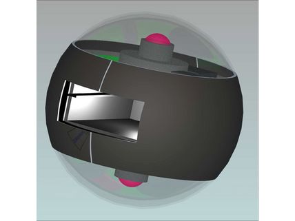
I can think of some great civilian uses:-) [Update: The BBC has a good story on it.] (Via Slashdot)
- GeoEye coming to Google Earth in January: All Points Blog notices the mention in a blog post on Portfolio.com.
- YouTube near you: YouTube’s API now lets you search by location. Combine this with Google Gears auto geolocation and you get: A YouTube search engine for videos near you. (Via Webmonkey via Via Lifehacker)