Want to see a 3D map that is OS independent today? Swedish search and mapping site hitta.se has just added an embedded 3D map of Stockholm to its web offering — one that only requires Java and works with Mac, Linux and Windows browsers. It is remarkably accurate and looks like this:
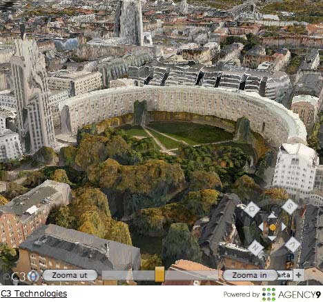
While Hitta.se has the working example, the 3DMaps EX software powering it is by Agency9, which in turn uses technology by C3 Technologies, a subsidiary of Saab, the Scandinavian military technology giant.
The technology is different to what Google and Microsoft are pursuing. Best to let the C3 site explain:
The technology is based on high-resolution aerial photography with carefully calibrated cameras. For every picture, the camera’s position and angle are calculated with extremely high precision, using a very advanced navigation system. This is what enables us to give each pixel its geographical position with decimetre accuracy. Then, using stereovision technology, we combine two sequential pictures to measure the area’s height profile.
The result is an aerial photograph with each pixel positioned in three dimensions. Over an entire city, thousands of such photos are combined into one coherent 3D model — through an automated process in our unique 3D-processor.
Thanks to all this, there is no one today who can take pictures with the same precision and speed as we can. One example is when we filmed all of Stockholm in October 2007 and created a realistic, yet zoomable and turnable, 3D model of the city in just 3 days.
Hitta.se’s FAQ is especially keen to explain how it is different from Google Earth. Translating and abridging severely now:
Google Earth’s 3D city models are built by traditional means. Because the used images are flat, Google Earth often misses out on displaying heights for buildings and trees. Hitta.se’s technology is completely automated. Any object larger than a VW bus is included in 3D in the final image. Google Earth has a limited numbers of buildings in each city. Hitta.se will show all the buildings in a city automatically.
Do go explore Stockholm for a while. My own take is that this technology is great for suburbs and wooded areas, where trees do make a difference. As for Hitta.se’s 3D buildings, they sometimes seem suffer from slightly misplaced textures, which gives them that Daliesque molten clock look. Still, this looks very scalable, though it is not clear how fast the Java engine is compared to Google’s just released browser plugin. I still prefer the details of Google’s and Microsoft’s “traditional” 3D models over 3C’s output, but I definitely prefer 3C’s output over a raw height mesh (DEM) model. (Via Dagens Nyheter)
Unfortunately my Swedish isn’t good enough to know what the pop up is telling me to do before I can go to the 3D map, and I would be very grateful if someone could provide a translation to English, plus any other tips on getting into the map.
click on the check box, then click on the button with “Till 3D kartan” on it.
I think its a cool application, but I’m not much of a fan of how it renders the city. It reminds me of a painted sandbox. Don’t get me wrong, its a very cool means to show Stockholm, but I was hoping for more sharpness in the way the buildings were drawn.