- Twipster: Here comes another entry in the “GPS mobile phone camera => georeferenced images published to the web” service space: Twipster, still in private beta, is described as “a geocentric mobile publishing platform. It can be used for many different purposes. You can use Twipster to do things like photowalk, tell a story, journal a vacation, geocaching, or just share memories.”
What sets it apart? It’s photo-site agnostic. Sure, you upload to Twipster’s site, but then you can further publish your photos to the likes of Flickr and Picasa. (Of course, competitor Shozu, not to be outdone, has just added that capability too.)
What’s not clear yet: When it comes to geotagging via Shozu, it currently works just with Flickr, using Flickr tags. Nokia’s Location Tagger, meanwhile, puts coordinates directly into the photo’s EXIF data, so that any site that can handle EXIF can georeference the photos. It’s not clear yet how sophisticated Twipster’s photogeoreferencing skills will be. In the meantime, the screenshots promise some nice graphics. (Via GenBeta)
- Static Google Maps API: Got a device that won’t do javascript? Want to cut down on overhead? Enter static Google Maps tiles referenced as URLs inside simple <img> tags.
You need a (free) API key, and there is a usage limit is 1,000 unique image requests per 24 hours. (Having your site request the same image more than once counts as just one unique image, however.) Note: You can get GIFs for two types of maps (standard and mobile), but not of satellite imagery or terrain.
The parameters are dead simple, and you can play with the Static Maps Wizard to get your image precisely. For example, I’m posting from here:
(Via Mapperz, who furthermore makes a list of the pros and cons of this static API.)
- KML2KML: Fresh from the creative imagination of Valery Hronusov, KML2KML, a stand-alone Google Earth application for the reorganization of KML datasets and creating view based regions in all KML or KMZ files ($50).
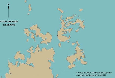
- Titan’s islands… mapped! Somebody is having way too much fun: Mr Minton of EVS Islands has taken some extraordinary imagery from Cassini’s Titan flyby, showing islands in a sea methane, and turned it into a map! The first of many such maps in the continuing annals of space exploration, no doubt…
Some bits for google earth lovers:
http://www.gr-navigator.com/kml/acc.kml
dynamically-updated list of Hotels in Greece to plan your Holiday
http://www.gr-navigator.com/kml/acc.kml
Real-time real-estate map for properties and rentals in Greece
Enjoy ;-)