Google has posted the list detailing the imagery and terrain update from December 16. The list is reproduced below the fold for archival purposes.
Several of these updates provide some great new context to existing stories. For example:
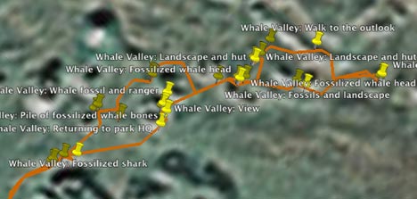
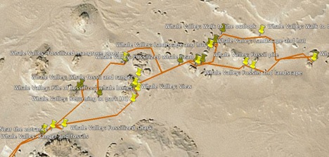
Egypt: A big chunk of Egypt gets 2.5m resolution imagery, so this is a great time to once again check the KML file of my field trip to Wadi el Hitan, Whale Valley, from May 2007. The remote shallow valley, which contains fossiled 40-million year whales, was previously in 15-meter resolution, and the imagery did not include the new road. Here is the before and after imagery:
Harare: The wholesale depopulation of a neighborhood of Harare was documented by the American Association for the Advancement of Science (AAAS) back in 2006. Google’s base imagery is now in high resolution, proving a third data-point for the KML layer.
New high resolution:
Americas:
- Canada: Significant amount of British Columbia
- USA: Jefferson City (MO), Central Virginia, Tioga County (NY), Cayuga County (NY), Jefferson County (NY), Broome County (NY)
- Brazil: Uberlandia
- Colombia: Cali, Pasto
- Mexico: Veracruz
Europe, Middle East and Africa:
- France: Le Havre, Dunkerque
- Poland: Poznan
- Russia: Yaroslavl, Ivanovo, Vladikavkaz, Volzhskiy, Barnaul
- Ukraine: Rivne, Odessa
- Morocco: Agadir
- Nigeria: Abuja
- Egypt: 2.5m imagery for eastern half of the country
Asia & Oceania:
- Japan: Kagoshima, Hamamatsu
- New Zealand: Manawatu Wanganui Province, Thames-Coromandel Province
- China: Guiyang, Zhaoqing, Zhongshan, Neijang, Anshun, Zhuzhou, Changde, Jiaoijang, Sashi, Qinhuangdao, Mudanjiang
- Indonesia: Sukabumi, Surakarta
Antarctica: new 15m imagery
Updated Imagery:
Americas:
- Canada: Calgary
- USA: Bend (OR), Reno (NV), Googleplex (CA), San Miguel (CA), Paso
Robles (CA), Buellton (CA), Thousand Oaks (CA), Los Angeles (CA), Orange
County (CA), Denver (CO), Saint Louis (MO), Knoxville (TN), Chattanooga (GA),
Dayton (CA), Atlanta (GA), Desoto County (FL), Onondaga County (NY), Cayuga
County (NY), McAllen (TX), Sanger (CA), Bellevue (WA)
Europe, Middle East and Africa:
- France: Nantes, Lyon
- Germany: Sindelfingen, Ausburg, Leipzig, Aachen
- Denmark: Entire country
- Niger: Niamey
- Zimbabwe: Harare
- South Africa: Johannesburg
- Iran: Tehran
Asia:
- Japan: Tokyo, Osaka, Nagano
- Thailand: Bangkok
- Vietnam: Hanoi
Updated Terrain:
- Massachusetts