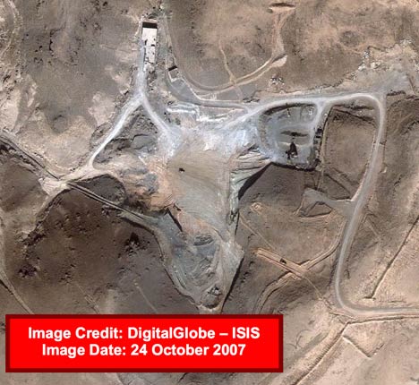
Via the BBC and also the NYT this morning comes word that Institute for Science and International Security (ISIS) have released some more imagery of the suspected attack site in Syria on September 6, this time taken last Wednesday, October 24 — just two days ago.
That square building? It’s completely gone! All that’s left is scrape marks and the odd bulldozer:
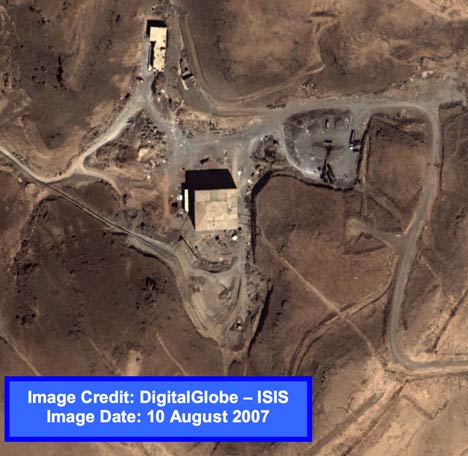
Compare to the imagery before taken before the attack, on September 6:
That just about confirms that this is indeed the spot. ISIS adds:
Dismantling and removing the building at such a rapid pace dramatically complicates any inspection of the facilities and suggests that Syria may be trying to hide what was there.
There’s more good analysis in the PDF.
I’ve turned both images in the PDF into high-resolution KML overlays. Get the KML file here. The August 10 layer is turned off by default, but turn it on and play with the opacity sliders to compare before and after imagery, as well as with the Spot Image base layer in Google Earth. Images don’t match up exactly because they were taken at oblique angles and are of hilly terrain.
Stefan – I really enjoy these posts involving Google Earth investigation/journalism from yourself. Thanks for putting the effort in and sharing – hopefully they’ll continue to be forthcoming.
Keith
I smell Photoshop there….
And I love the smell of conspiracy theories in the morning.
Really, how could this be photoshopped? The images are commissioned by an independent organization directly from DigitalGlobe. Soon, you’ll be able to buy them yourself directly online. Are you saying that DigitalGlobe is colluding with dark nefarious forces? Don’t you think they’d be found out next time Spot Image flies by? Or is Spot Image also in on the secret?
Photoshops can be detected through forensic analysis. Basically, the changed parts will have different entropy from the rest of the image. There are tools to show this visually.
I suggest anyone ‘smelling’ a conspiracy should do a google search on how to spot a fake image and find out of their nose is functioning properly before similarly using their mouth.
The International Herald Tribume reports that Spot Image also has recent imagery showing an empty area.
Gov sensors will have the intermediate images of the debris field, as well as the Syrians working on the site afterward (with the apparent excavation work).
What I find curious is that the GE images don’t include the long secondary building in them, but the ones acquired by ISIS do. Both sets of images are are taken in August, 2007. Are the GE images mis-dated, and are in fact from an earlier time?
We don’t know on precisely which day the base layer in GE was taken. It’s Spot Image imagery, not DigitalGlobe, so you can’t use the DigitalGlobe meta-layer to find out. The Spot Image metalayer for that area doesn’t show the 2.5m imagery, so you can’t use that either. Most likely date for the base layer is early 2007.
Thanks for the clarification. I was indeed relying on the DigitalGlobe metalayer for dating the images. It’s a shame GE doesn’t include accurate and complete dating of their imagery!