Neocon Express is quick to take credit for having found the alleged Syrian reactor on Google Earth soon after if was bombed by Israeli jets on September 6:
Not long after hearing about the Israeli raid on September 6th, I did a quick search on Google Earth, and easily found the suspected facility that was bombed (although I wasn’t sure that that was the exact facility until the images became public).
That’s quite a remarkable achievement, considering that until October 23, the imagery of the location in Google Earth looked like this:
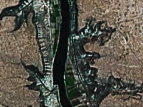
Only with the Oct 23 data update did the building become visible in the Spot Image 2.5m imagery that was added to Google Earth on that day. ISIS released its commissioned high resolution DigitalGlobe images on October 24. If you’re quick, you can still see the pre-Oct 23 imagery in Google Maps.
Then again, the neocons are so deep in denial about their failed approach to the Middle East, what difference does one more lie make?
And isn’t forensic neogeography fun?:-)
Meanwhile, in other Syria-related news:
- The New York Times carries an article showing a GeoEye image taken from September 16, 2003, showing that the rectangular structure existed then.
- ISIS releases another PDF, this time highlighting the fact that the Oct 24 imagery shows part of the mountain removed — the thesis being that this dirt was used to bury the building’s foundations.
I think the proper term for that site is neotard.
I like that one, Avi. It’s almost as if Strauss himself wrote that.
Nice catch. David Albright was the first to find and post the site. Moreover, the picture that the Neocon Express shows while falsely claiming to have found the site first on Google Earth is actually the 2003 GEOEYE image first published by the New York Times. Note that there is no structure on the river and it doesn’t match the appearance (color) of the 2.5 Meter SPOT Image image that was recently added by Google Earth. Also the slightly distorted “aerial” image of the Yongbyon reactor is a Digital Globe image (i.e. satellite). Just can’t trust those neo-cons. :)