
Amnesty International today launches Eyes on Darfur, a project whose major component is a website that focuses on 12 specific Darfur villages, the intention being to depict the ongoing tragedy on a human scale as a way of motivating visitors to take action:
Eyes On Darfur also breaks new ground in protecting human rights by allowing people around the world to literally “watch over” and protect twelve intact, but highly vulnerable, villages using commercially available satellite imagery.
In practice, this means that a Flash application (why-oh-why break the browser’s back button and lock the satellite imagery into a proprietary format?) makes satellite imagery available to visitors that is just weeks or months old, and often also photos from before attacks.
Every initiative on Darfur is a worthy initiative. I would love, however, for this weeks-old data from Darfur to be made available in an open, georeferenced formats, in time series and on a much wider scale, so that GIS volunteers really can monitor villages for change. I’d gladly “adopt” one of the 1,600 villages and monitor it, given the data. I also think Flash is not the best visualization tool for geospatial data — there is not the natural flexibility with layers and such that lets this content be truly compelling and immersive:
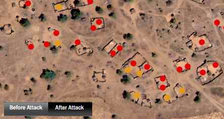
The dots show destroyed structures, but cover those said structures, and you can’t take them off. So I hope this new data also makes it into Google Earth.
With Flex, it’d be possible to make it fully immersive – but – that day will come in time. Right now, I think for high-profile projects like this, it’s best to serve the information and data to the masses in a tool that’s already well-received and allows for linking datasets directly from web pages. Google Earth, for example!
Why they didn’t use a single-pixel line to indicate location – or – at least offer a button to remove the dots is beyond me. Or, do what I do and create masked swipe so you can see the differences between dates.
we want to see the crisis come down by UN.
Hi, my name is Bashir I work for the media clubhouse islington, I am from sudan “Darfur” I would love to know more about your projects in Darfur, and if I could help at all, as we are a media centre we are planning to make a short film about Darfur, is still just an idea, we haven’t done anything about it yet
my e-mail is islingtonclub@csv.org.uk
this need to stop
this need to stop