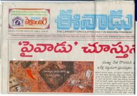
The missing URL of the blog post by Harish Kumar Bhamidipati that served as a source for the Hydarabad land scam story has now been found, and it comes with a translation of the original newspaper article in Hindi Telugu that started it all. It’s a great read. Google Earth does indeed play a starring role.
Here’s a highly abridged version of what transgressed: As part of a general amnesty, houses built before 2001 on plots of illegally sold land were “regularised”, and thus allowed to be resold on the market. Somebody with government connections got the bright idea of “backdating” some houses built after 2004, pretending that they were there since 2000, so that they could benefit from the amnesty and sell them. Digital Globe imagery from 2004 in Google Earth quickly put paid to that lie.
In a sign the state government is both clueless and in trouble, it maintains that the images were doctored (according to the blogger’s dad). How cunning of Google!
Seriously, though, this argues strongly in favor of keeping archives of successive generations of Google’s base layer. Google Earth Pro lets you access different datasets; why not make older ones available there as a pay service? (Added bonus: placemarks of time-sensitive artifacts like planes in flight could be metatagged to a specific generation of imagery.)
Fascinating story…I’ve been following it with interest since your first post on the topic…and i couldn’t agree more with your suggestion of old images and layers being made available.
What I would really like to see is time as an axis in google earth – there is obviously some excellent uses for this in urban areas but also rural and environmentally sensitive areas – take retreating glaciers as an example
Do you know if anyone is doing this? How hard would that be to fit it within google earth’s structure?
Look forward to reading the next instalment of the hyderabad land scandal!
The newspaper article is in Telugu,not Hindi :-)Because it was in Telugu, I had to ask my dad to translate it for me.
Will try to post further updates on this.
I am a big fan of keeping history layers available as well.
In addition, I would like to have available historical layers that have not been in Google Earth to this point. Most of the US has had regular aerial photos taken since the 1940’s, so it would be fascinating to track development, decline, land use and all sorts of things.
Tony