- Here’s the Google Earth KML 2.1 Tutorial. Everything you’ve ever wanted to know about KML 2.1 since a few hours ago.
- And here’s the KML 2.1 Specification.
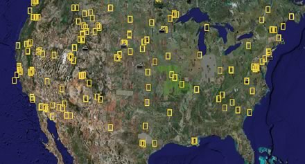
- Frank at Google Earth Blog points out that the National Geographic Layer now contains plenty of placemarks over North America, not just Africa.
- Remember that Google Earth 4.0 is _beta_. After some heavy use, my copy started to crash repeatedly as I zoomed over a specific region. Trashing the settings file didn’t help. Trashing the cache file did.
3 thoughts on “KML 2.1 specs, tutorial; National Geographic update”
Comments are closed.
Hi Stefan,
Regarding the Beta, the XP and the Linux version seems to be worked perfectly (just a conflict under XP between the free beta and my Pro version (who can’t log me on GE server)then I decide to remove…. the free version (hehehe)and the Pro run again :o)
Great coverage Stefan!
Aside from the coolness of textures in GE4, I think the new KML in Google Maps feature is fantastic. I found this morning that you can also use a proxy URL as your link to KMLs in Google Maps. For example, using a tinyurl.com url. I don’t know if this has any application what so ever, but it seemed interesting.
Keep up the great work!
Hi. Just a quick note about the linux version and the Bitstream Vera Sans font…
When running Google Earth on various versions of SuSE linux, an error message is displayed stating that the Bitstream Vera Sans font is not installed. I reported this issue to the linux folks at Novell and the response I received was:
They are not installed by default by intention as DejaVu are the better fork of
them and today’s distribution (SUSE, Fedora, …) use DejaVu by default. You
better report that to Google.
Anything we can do about this? Thanks for a great product. I really enjoy Google Earth.