Sweden’s Lantmäteriverket, the state GIS agency, has been caught camouflaging its censorship of the country’s spy headquarters on aerial images it makes public, and Google Maps is directly responsible for the find.
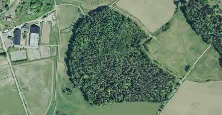
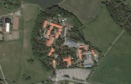
It started when Eniro, a mainstream search and mapping site for Sweden, decided to use Lantmäteriverket’s images to add aerial shots and hybrid maps to its mapping service, much like Google Maps does. A publication eventually noticed that the aerial data provided by Eniro and Google don’t match in a special spot on the outskirts of Stockholm. Here is Eniro’s image:
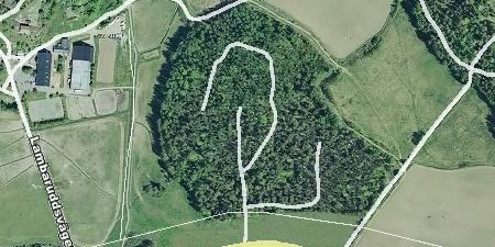
What’s even more absurd is that Eniro’s mapping service actually has the roads and buildings, so the hybrid image looks like this:
(Incidentally, Google Maps and Google Earth don’t have the same dataset for this location — Google Earth’s has a random cloud covering the crucial spot.)
It turns out that Lantmäteriverket employs a person whose job it is to camouflage its censorship by painting over buildings with trees and fields. The story made it to Sweden’s lagest tabloid on Thursday in mangled form (of course), as blogged by Patrick Strang (in Swedish). Strang also rightly points out that the only effect of such camouflaging, where you are lied to about the true information content of a map, is to distrust all maps by the same source, in this case Lantmäteriverket. It makes these maps less than useless, especially when Google Maps and Earth is around. And it is behaviour unbefitting an open society. If you need to censor something, fine, but don’t hide the decision. That way lies 1984.
Another interesting tidbit: The agency said it does not have a problem with Google’s images, as they are satellite-based, and hence outside the jurisdiction of Sweden, whereas the images it can censor are taken from planes that fly within its jurisdiction. Countries do indeed have a monopoly on sovereignty in the air, and not in space.
(Early datasets for Google Earth also used images of the White House where censoriship by a US agency was camouflaged, as blogged here.)
[Update 2006-04-10: There’s two further updates to the story, in the meantime: Yes, we have no Swedish spy base and Sweden: Watching the watchers (with Google)
Hi Stefan,
Nice post ! I translated it in french .o)
The resolution of the picture from google looks to be something like just under 1m. Doesn’t that mean it came from a plane?
no. satellites now have somewhere around 10cm/px or better resolution.
It looks like maybe Google is also censoring the satellite images also. I looked at it in Google Earth and there is a very white cloud right over the agency site. If you look at it in google local you can see the site. What makes it looks like it has been censored is if you look at the the google local picture there is one cloud, in the google earth picture there are two clouds. Then compare the clouds. The left cloud on google earth looks just like the cloud in google local. I have a screen shot of both if you want to see them.
Jody, the tile on the left is the same for both, but Earth and Maps have a different tile on the right. You can see it if you zoom out. It happens.
Interesting.
Your statement about trusting other images from the same organisation is interesting also and raises another point…
If someone buys imagery on the basis of accuracy (a contract) and later finds out that it has been altered, then could they seek reimbursement?
The net effect is that no agency can then guarantee any sort of quality.
I will note that NASA and the World Wind group (http://worldwind.arc.nasa.gov) does not censor their map data.
Adam, Neither does Google. Any censorship that bas found its way into Maps and Earth until now has been because providers have altered it at their government’s behest. If NASA World Wind were to go for highly detailed data, it would face the same challenges.
Once censored areas are noted in Google Earth (mainly in the US) they tend to disappear with the next update. Case in point: The White House, which is now clear as a bell.
Censorship? Use a dictionary to leran what that means.
leran? use a dictionary to learn how to spell.
Big difference between using the correct definition of a word and a simple typo.. unless you are distracting from a point you cant back by picking on something else..?
Lets compile all the “spy agencies” of the world !
Here is the french one, in Paris, called the DGSE.
I checked the definition, what is wrong with calling that censorship?
I don’t know what the big deal is. Don’t Swedes want their national security protected? Standing up for freedom of information on principle is well and fine, but that data could theoretically be used to plan a terrorist attack, and is there anyone in the world who is really harmed by not being able to see the satellite imagery of that complex?
It’s not as if Lantmäteriverket was muzzled – they are a government agency and probably were more than happy to comply. And extrapolating this to say that the legitimacy of all of Lantmäteriverket’s maps are now in question is a little far fetched. I’m going to go out on a limb here and say that life in Sweden will go on like normal tomorrow and no one will have to be admitted to the emergency room.
1. There is censorship, and then there is outright fabrication, which is worse. Pixelate away if you have to, but in an open society citizens have to be able to keep tabs on their government, and they can’t do that if the government can obfuscate decisions on what it censors. In the US, censored documents have big black lines through the offending bits. That’s different from rewriting the pages to make it look like there is nothing there that needs to be censored. The situation is analogous here.
2. Lantmäteriverket turns out to sell uncensored images on its own website. So there is an element of hypocrisy involved when it puts spokespersons in front of the camera explainin why it is a good thing to paint over anything it chooses needs “protection”.
3. This is 2006. Everybody knows where everything is. All you have to do is make sure you don’t use imagery issued by an official agency for the region you’re interested in. The best an agency can hope for is to not unwittingly offer the highest resolution imagery around. Hence why I could live with pixelation. That way you are not lying to your constituents.
The map (Karta) on Eniro even has the outline of all the buildings in this ‘secret’ complex!
See
http://maps.eniro.com/servlets/se_MapImageLocator?profile=Main¢er=1616635;6580971&zoomlevel=7&size=490×420
Note: the img tag is unfortunately not allowed in comments.
First of all it’s not a question about censorship to hide the facilities, you can find their address easily enough and I suspect that you can get quite close to the facilities without breaking any laws. The reason that the facilities are not shown on the maps is because there’s a law against taking photos of them. The reason that Lantmäteriverket decided to paint trees over it is because it looks much better than a large black square covering the area.
The Gobernment Satellite’s resolution are secrets right now… they wont say that they have a 1mm/pixel resolution… it’s secret… when they send a new one… better of course, they give the old one to some company… military always have the better onces… EEUU, China and Russia are the most powerfull coutrys in this technology
I know this cause 4 years ago i worked in a gobernament facility and they teached me a lot…
Belive me… there are too many things you wont understand… everything ALWAYS is planed…
“The reason that Lantmäteriverket decided to paint trees over it is because it looks much better than a large black square covering the area.”
I doubt it. Pixellating is a far more honest and useful way of marking off censored regions. I believe the reason the censorship in this image was camouflaged is because during the Cold War, the location of the listening post was in fact a secret.
And if the choice is between a large black square or fake trees, though not knowing where they might be… Would you really choose fake trees? Fabrication like that actually subtracts value from an image.
Splendid information – this will certainly be used in my collegeproject :)
The problem with Stefan is that he is getting overexcited about something that no normal person here pay the least attention to.
So if those buildings are there, who cares?
Besides, I have used many of Lantmäteriets maps,they are very good.
And they are doing an excellent job in giving us access to their historical maps.
The spycentral is hidden but you can count the planes on swedish airforcebases
and i will say NASA WORLD WIND is a spion program where is spioning you
My little brother says: BTW, if you want to see some censorship, use Google maps to look at
south east Cuba, and you will find sections of the surroundings of a
certain bay covered by animated drawings. And those clouds…I don’t
think so.
If you look up Swedens biggest airforcebase, you can see the plane refuling, C-130 Hercules and SAAB 39 Gripen