![]() Today’s must-see destination for ardent followers of virtual globes is a blog post by a French technology consultant, Jean Michel Billaut, who has put up an 11-minute video of France’s upcoming GéoPortail in action, demonstrated to him by Patrick Leboeuf, the man behind the whole initiative at the Institut Géographique National (IGN).
Today’s must-see destination for ardent followers of virtual globes is a blog post by a French technology consultant, Jean Michel Billaut, who has put up an 11-minute video of France’s upcoming GéoPortail in action, demonstrated to him by Patrick Leboeuf, the man behind the whole initiative at the Institut Géographique National (IGN).
Granted, the whole thing is in French, but in this case the images speak for themselves. Some highlights:
- What is being shown is the 3D version, which looks like a dedicated Windows application with a similar layout to that of Google Earth. The 3D version will be out early 2007, whereas a 2D version will be out this summer.
- The video shows off some impressive capabilities, albeit just for France and its territories. Resolution will be 50cm per pixel for all of France, and it works smoothly on the laptop used in the demo. Development looks to be far advanced, certainly at a Google-beta level.
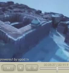 The single-most impressive part is when Leboeuf shows off texture-mapping for 3D building facades, taken from real photographs (5:20). He says that they plan to have this operational for the city of Toulon, for starters.
- In addition to aerial imagery, the video shows that there will also be topo maps and property maps (7:50) available, and 3D buildings (4:48), roads (4:30), all French postal addresses (7:10), and more. Some of these features will be pay services.
- Leboeuf says that while IGN, being a French government agency, owns the data that GéoPortail renders, it is not the exclusive provider of these data (10:40) — Google Earth is free to purchase them, he says.
Overall, this demo of GéoPortail gives us a glimpse of some amazing new features that are just around the corner for geobrowsers, made all the more remarkable by the fact that it is the product of a government push to democratize access to the geospatial data that it possesses. (Via Innis)