Imaging Notes magazine has published high-resolution satellite pictures taken by commercial operator Digital Globe of a “secret” tunnel for China’s nuclear submarines. The tunnel is easily located on Google Earth with a bit of sleuthing.
Here is a Washington Times story about the image, here is the actual image by Imaging Notes, and here is the page documenting the site by the Nuclear Information Project, which includes an account of how the tunnel was built.
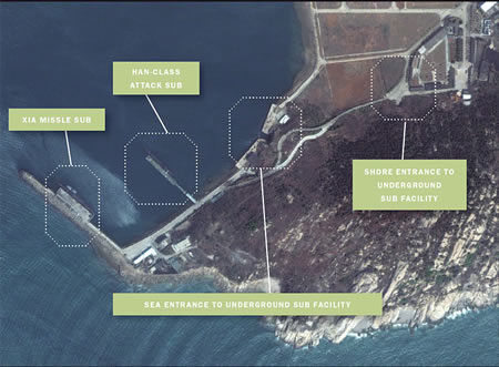
I’ve turned the images into overlays at the correct location on Google Earth. Here is the KMZ file, posted to Google Earth Community.
Suddenly, last month’s thought experiment is no longer so abstract.
This is but one example of how I have been able to map the subterranian Earth. Google Earth has enabled me to open portals on the grid and explore the underground world. I am currently mapping all the inner workings under North America and their connections. The tunnels and caverns are spectacular. Before this it was pure fantasy. We are now able to research from inside the Earth.
Are you aware that if you look in google earth at the place you have done the image snippet of, about 550 meters due N of the water entrance to the sub tunnel there is a balistic missile submarine in drydock, either being built or repaired?!!!?!?!!!
cheers
Gross!!!!
The fact someone built such a place and the fact we can see it from space…..
GROSS!