There’s only three posts so far, but one of them turns this new Google Earth blog into a must-see. Mart√≠n Cadirola’s Using Google Earth for Earth Science and Remote Sensing exists “to get my fellow colleagues at NASA and other organizations and agencies acquainted with Google Earth and its potential for integrating, visualizing and collaborating information.”
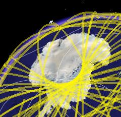 And how. Mart√≠n posts a few “samples of KML files” in this post. The last one, Orbital satellites [KML] contains an orbital snapshot of every satellite I’ve ever heard of, and plenty of other ones too. It looks gorgeous. It’s not live, but it could be, and as such it works well as a lovely piece of eye candy and as proof of concept.
In this post Martín links to a PowerPoint presentation online that he used to introduce Google Earth as part of a pitch by his company to help NASA use the application to visualize their mountains of data. The possibilities he outlines seem broad indeed.
Stefan, the satellites one was done by a bunch of amatuer radio enthusiasts. You can read about it here: http://www.gearthblog.com/blog/archives/2005/10/800_satellites_1.html
and at the GEC here:
http://bbs.keyhole.com/ubb/showthreaded.php/Cat/0/Number/150459/page/0
Hmm. That shows the importance of attribution when linking to other people’s work. (Though perhaps the blog isn’t intended for a wide audience.)
Finally having Google Earth (for Mac) on my machine should mean that I actually get to play with all these layers. And perhaps even remember them:-)
Dear Stefan/Frank,
I didn’t know my blog was going to reach so many people (my blog was just released on Wednesday).
Indeed, the “orbital satellites” kml file was developed by a great group of ham radio gurus ( http://www.openAPRS.net and http://www.n6nar.org.) I added the reference to my blog so that we set that clear.
Thanks also for writing about my thoughts on using Google Earth for science purposes!
Martín
thanks for providing examples of thinking and working in 3D. not just for the living space but larger spaces.
This has been my field since mor than 2 decades.
I show your examples everywhere but feel you urgently have to move as google earth into the field of locating places on earth like frappr – as THE EARTH IS NOT FLAT.
As FRAPPR starts from an distorted – on-equal area projection – people and pupils get the wrong fealing about proportions and consequences.
3D s EQUAL AREA and can help!
not just for environmetnal applications.
anyone intersted might want to look into EARTH LITERACY and MAP ALPHABETISATION
http://www.in-betweener.org/flatworlds/
where I write on ne cartography about FRAPPR; OGLE EARTH – GOOGLE EARTH
http://in-betweener.org/flatworlds/maps/new-digital-worldmaps.html
or might want to dig into KNOWMAP differentiating spacial and spatial:
http://benking.de/Global-Change/spatial-spacial.html
or much deeper (older) into early 3d colour and HIS and what we wrote in 1987 for the GERMAN Society for informatics about visual demagogy and
http://benking.de/GI/GI-datavisual-1987.html
or GEO ECO DYNAMICS
http://benking.de/Global-Change/GeoOekoDynamics-1988.html
dear Ogle Earthians I hope you are rady to start with me into 4D and 9D in what I call a “cognitive panorama”:
http://benking.de/systems/encyclopedia/newterms/
entry 0479 in the INTERNATIONAL ENCYCLOPEDIA OF SYSTEMS AND CYBERNETICS….
cheers
heiner
I found a website I do like to recommend one software that contains PictureViewer .EXE, Image Converter .EXE and Image Merger .EXE,that is,
Picture Viewer and Converter Suite,http://www.qweas.com/
have a good time!
Qweas Software Search Engine
offers services including software search, downloads, store, directory, and so on.. You can find useful soft wares for you.