Until this morning I had never heard of the XAlps, “the ultimate paragliding race,” where contestants paraglide 800km across the Alps, east to west, without mechanized help. The race started today, August 1, in Austria. You compete by climbing to the tops of mountains with your equipment and then jumping off, gliding as far west as possible, climbing up the next one, jumping off, and repeating this all the way into Monaco.
I found all this out via Geared Up blog, which also pointed out that the 17 contestants this year are wearing GPS trackers, whose data get turned into Google Earth KML files, available for download.
Aha! The future of sport, I thought, only to find the reality akin to making it to Lake Geneva and then drowning: The KMZ files are very hard to find, are offered as static downloads, and even then only on a per-contestant basis. That’s so close, so why not go the last mile?
Luckily, the individual KML files automatically get published to the same URL and are regularly replaced. This made constructing dynamic network links out of the 17 files and collecting them into one downloadable, annotated KMZ relatively straightforward.
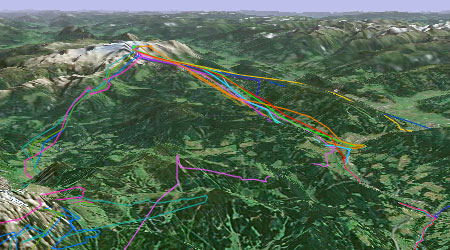
I’ve set them to update every hour. The gliding paths they produce are wonderful, punctuated by climbs up the next hill. It’s truly the best way to see this race, and every future endurance race. (I’m rooting for Team 9.)
It looks amazing when you deselect all other placemarks etc. in Google Earth and then let it play the track, trying to get a feel for the path the competitors took. Its really amazing how far some of them have comme in such a short time. But then one of the short-commings of Google Earth come to light, as the camera tracks the path, instead of letting the camera folow the path it tracks the ground beneath even though theres altitude data from each part of the track.
Hey, Blogger of Geared Up here! Wow! I’m so impressed you read my blog and featured it! I have just gotten a major major energy rush to look after it properly now and start tagging it! Thanks for your feature!
i ned live map and eimaag to kuwait sete
Why is google earth so blurry when I zoom in on Canada? (at 500′)
The place to go for those kinds of questions is
http://bbs.keyhole.com/